5 Anni Syarifah-Plantu0026Picnic - a year ago
Wanna there


5 Anni Syarifah-Plantu0026Picnic - a year ago
Wanna there
5 Syamsul MgL - 3 years ago
(Translated by Google) Still cool .. But the temple syngny has collapsed ... But even though it's interesting for the knowledge ...
(Original)
Tmpt sejuk.. Tp syngny candi udh runtuh.. Tp meski bgitu ttp menarik untuk pngetahuan...
5 Dodi Dodi - 4 years ago
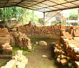
(Translated by Google) This site is located at an altitude of 867 m above sea level. The first research at the temple site which has an area of u200bu200b100 x 40 m, was conducted by the Yogyakarta Archeology Center and the Historical and Archeological Heritage of Central Java in 1989. The research resulted in the discovery of two pairs of cheek stairs of a temple whose stairs are different and are thought to be still in situ . The stairs on the cheeks I face westward and the stairs on the cheeks II face northeastward. Other findings are in the form of ruins of the temple stones, some of which have been taken by local residents.
Other findings from excavations carried out at the Batur Temple Site are earthenware fragments, brick fragments, charcoal, stone blocks, plain stone structures in front of the cheek of stairs I, and the structure of the remains of temple buildings in the form of gravel and rock tiles in front of the temple. The three pottery fragments that were discovered were thought to be on a plain stone structure that was thought to be the floor of a temple courtyard. From the results of surveys and excavations conducted show that the Batur Temple Site is a temple that is used as a place of religious activities at the time. If you look at the location of the temple on a hill that is quite flat with right and left cliffs, it is estimated that Batur II Temple was deliberately erected on that hill. The hill was made in such a way that the top of the hill became a fairly large flat area of u200bu200b+/- 4,000 m2, most likely the people made it by cutting the hill. While the distance between the two cheek stairs is 41 meters, and
it is possible that one of them is the staircase cheek going into the temple and the other staircase cheek is the entrance to the temple fence.
(Renville Siagian, Temple as an Indonesian Cultural Heritage, Cempaka Kencana Foundation, Yogyakarta, 2002, p. 49)
(Original)
Situs ini berada pada ketinggian 867 m di atas permukaan laut. Penelitian pertama kali di situs candi yang memiliki ukuran luas 100 x 40 m ini, dilakukan oleh Balai Arkeologi Yogyakarta dan Suaka Peninggalan Sejarah dan Purbakala Jawa Tengah pada tahun 1989. Penelitian menghasilkan temuan dua buah pasang pipi tangga candi yang berbeda letaknya dan diduga masih in situ. Pipi tangga I menghadap ke arah barat dan pipi tangga II menghadap ke arah timur laut. Temuan lainnya adalah berupa reruntuhan batu-batu candi yang sebagian sudah diambil oleh penduduk setempat.
Temuan lain dari hasil ekskavasi yang dilakukan di Situs Candi Batur yaitu fragmen gerabah, fragmen batu bata, arang, balok-balok batu, struktur batu polos yang berada di depan pipi tangga I, dan struktur sisa-sisa bangunan candi yang berupa kerikil dan tatal batu di depan candi. Tiga fragmen gerabah yang berhasil ditemukan diperkirakan berada di atas tatanan batu polos yang diduga sebagai lantai halaman candi. Dari hasil survei dan ekskavasi yang dilakukan menunjukan bahwa Situs Candi Batur adalah sebuah candi yang dipergunakan sebagai tempat kegiatan keagamaan masyarakat pada saat itu. Jika melihat keletakan candi di atas bukit yang cukup datar dengan kanan kiri jurang, maka diperkirakan bahwa Candi Batur II memang sengaja didirikan di atas bukit itu. Bukit tersebut dibuat sedemikian rupa sehingga puncak bukitnya menjadi tanah datar yang cukup luas +/- 4.000 m2, kemungkinan besar masyarakat membuatnya denganjalan memotong bukit itu. Sedangkanjarak antara kedua pipi tangga adalah 41 meter, dan
kemungkinan salah satunya merupakan pipi tangga masuk ke candi dan pipi tangga yang lain merupakan pintu masuk ke pagar candi.
(Renville Siagian, Candi Sebagai Warisan Seni Budaya Indonesia, Yayasan Cempaka Kencana, Yogyakarta, 2002, hal. 49)
5 Ari Prasetyo - 2 years ago
(Translated by Google) This temple site is only ruins
(Original)
Situs candi batur ini hanya tinggal reruntuhannya saja
5 wahhab anang - 2 years ago
(Translated by Google) In Cagarbudaya
(Original)
Cagarbudaya

Candi Selogriyo
H5G9+43R, Hutan, Windusari, Kec. Windusari, Kabupaten Magelang, Jawa Tengah 56152, Indonesia

Kedai kopi selogriyo
candi selogriyo, Campurejo, Kembangkuning, Kec. Windusari, Kabupaten Magelang, Jawa Tengah 56152, Indonesia

Candi Selogriyo, Entrance Gate and Ticket Office
H5GG+CXH, Unnamed Road, Hutan, Kembangkuning, Windusari, Magelang Regency, Central Java 56152, Indonesia

Villa Sumbing Indah
Jl. Raya Kalegen, Kiringan, Kalegen, Kec. Bandongan, Kabupaten Magelang, Jawa Tengah 56151, Indonesia

Curug Delimas Girimulyo
H4Q9+C7Q, Dusun Kuadaan, Desa Girimulyo, Kecamatan Windusari, Dampit, Kec. Windusari, Kabupaten Magelang, Jawa Tengah 56152, Ind

WANA Mukti Siguede Kebonlegi
Jl. Raya Bandongan-Mangli, Area Sawah, Kebonlegi, Kec. Kaliangkrik, Kabupaten Magelang, Jawa Tengah 56411, Indonesia

Bakso Pak Rin
G5R7+C56, Jl. Bandongan Kaliangkrik, Krajan Dua, Tonoboyo, Kec. Bandongan, Kabupaten Magelang, Jawa Tengah 56151, Indonesia

Bakso dan Mie Ayam pak Slamet
G5PF+HQ7, Jati Lor, Tonoboyo, Kec. Bandongan, Kabupaten Magelang, Jawa Tengah 56151, Indonesia

Bakso Jumbo Mas Anom
G5VV+3J6, Jalan Raya, Jetak, Sidorejo, Bandongan, Magelang Regency, Central Java 56151, Indonesia

Warung Ijo
G5RV+VHC, jetak I, Gumuk, Sidorejo, Kec. Bandongan, Kabupaten Magelang, Jawa Tengah 56151, Indonesia